
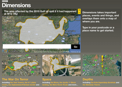
This is one of the best BBC projects I’ve seen in a while: Dimensions maps key events, places and things such as the Pakistan floods, the Gulf oil spill and the Afghanistan-Pakistan border – over your postcode.
It’s a simple idea, but hugely effective.
The prototype comes not from the corporation’s News arm – it was commissioned by History. Commissioning Executive for the Multi-Platform Team Max Gadney writes:
“Our challenge was to make it relevant to audiences.
“This is a common desire. Commissioning editors often want stuff ‘made relevant’ – TV producers might translate this as putting a celebrity in it – one we can relate to (Who Do You Think You Are does this very well). How does digital media make something relevant?”
Currently this is a prototype, so feedback is welcomed. I hope that News will be rubbing their hands at the potential applications and making their own suggestions for improvements on those lines.
For once we may be able to stop comparing things to the size of Wales. Unless, of course, you have a Welsh postcode.

Pingback: Conexão TE » Blog Archive » Dimensions – sobrepondo eventos históricos sobre o mapa
Pingback: Dimensions – sobrepondo eventos históricos sobre o mapa « Enio de Aragon